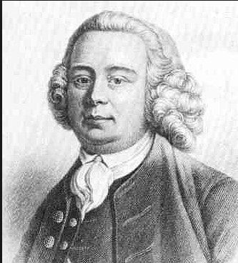
Before this journey starts it's important to acknowledge the genius of James Brindley, known as the Father of the canal system. Born into a farming family in Derbyshire in 1716 he became a Millwright. His work on the construction and repair of water mills gave him an understanding of managing the flow of water and it was when he took on the job of building a canal for the Duke of Bridgewater to transport coal from the mines that his skill as a canal engineer became apparent. The Bridgewater canal was a great success and other industrialists soon wanted canals on their land to transfer goods. This was the beginning of the canal system that we know today.
A rapid increase in canal construction followed; The Trent and Mersey Canal (Act 1766, completed 1777) and The Coventry Canal (Act 1768), being early examples.
Sir Roger Newdigate, MP for Oxford University and owner of several coal mines in the midlands, then visited Banbury and held meetings (April 1768) with the Mayor and other prominent land owners and industrialists, to promote the building of a canal from Coventry to Oxford.
As a result of these meetings, Brindley was retained to survey a potential route and produce preliminary plans. These were subsequently altered to overcome the objections of Lord Craven and Lord Denbigh, over whose land the initial proposed route would have run.
These revised plans were submitted to a meeting held at the Three Tuns in Banbury (October 1768), chaired by Sir Roger, and attended by potential investors and local landowners. These included the Dukes of Marlborough and Buccleuch, representatives of Banbury and Oxford councils, the local turnpike trusts, and from the Coventry Canal. A resolution to proceed with the proposed canal was agreed, and a subscription of £50,400 was made to finance the preparation of a parliamentary bill. The petition for the bill was submitted to the House of Commons on 29 November 1768. There now followed a period of dispute between the backers of the canal and their opponents. These mainly revolved around the vested interests of the existing coal trade (shipped by sea from the north-east and then up the Thames), the potential loss of income from road and river tolls, and conservative landowners who wished to maintain the status quo. The bill was eventually passed by the House of Commons after a number of compromises were made, and passed on to the House of Lords. The Lords rapidly passed the Bill and it was given Royal Assent by George III on 21 April 1769.
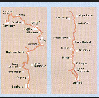
The Act gave the canal route as Ansty, Shilton, Brinklow, Newbold, Hillmorton, Braunston, Napton, Wormleighton, Cropredy, Banbury, King's Sutton, Aynho, Souldern, Heyford, Shipton, Thrupp, Wolvercote and Oxford, although minor changes would take place during the building period. The Act allowed for the construction of branches to any limestone quarry within 5 miles of the canal route as long as two-thirds of the landowners over whose land the canal passed agreed to it. The Act also allowed the canal company access to any water supply within 5 miles of the summit pound in the Chiltern Hills. To protect the interests of the traders using the canal, the Act stipulated the maximum transport fee of ½d per ton per mile, and that materials for the repair and upkeep of roads was to be transported free of cost.
The first meeting of the newly constituted Oxford Canal Company took place at the Three Tuns on 12 May 1769, and working capital was raised by the issue of 1500 £100 shares. Brindley was appointed engineer and general surveyor, Samuel Simcock as his assistant, and James King as clerk. Bricklayers and a carpenter were recruited and sent to canal works in Staffordshire to learn the specialist techniques that would be required, and a recruitment drive was begun to enlist the many local suppliers and labourers that would be needed.
Brindley prepared the final plans, and these were presented to a meeting on 3 August 1769, where they were agreed. The first cutting subsequently took place at Coney Lane, Longford (at the junction with the Coventry Canal) during September 1769. This junction with the Coventry Canal was soon moved to Hawkesbury to remove the necessity of the canals running parallel for one mile.
During December 1769, all the canal companies operating in the midlands agreed a standard lock size to accommodate boats of 74ft 9ins x 7ft x 4ft 4ins, thus setting the size of the narrow canal system. The Oxford Canal was being built with a bottom width of 16ft, allowing two 7ft wide boats to pass. The water depth was 5ft , with a 7ft wide towpath, 1ft above the water level.
Around 700 men were now employed in cutting the canal and by March 1771 the first 10 miles had been completed.
Unfortunately, in September 1772 Brindley fell ill and died leaving Samuel Simcock (his assistant and brother-in-law) to take over and continue the work .
By 1774, 40 miles of the canal were open (from Coventry to Napton), and being used to transport coal for onward shipment to Oxford, Banbury, Bicester etc by wagon. Funds for construction of the canal were running low and another act of Parliament was passed in 1775 allowing the Canal Company to raise further capital. Much of the money had been spent on two major construction projects; the aqueduct at Brinklow and the tunnel at Newbold. By May 1776 the canal reached Fenny Compton and income from tolls had increased to the point that the canal was already making a profit of £206 5s, despite its incomplete state. A further tunnel was constructed at Fenny Compton which stretched for 1138yd (just over a kilometre). This was later converted into a deep cutting during the 19th century. To provide an adequate water supply to the summit pound, it was cut 1½ft deeper, and reservoirs were built at Byfield Water and Clattercote.
The canal reached Banbury in 1778 and the first delivery of 200 tons of coal to the wharf at Banbury was met by a large and enthusiastic crowd of spectators on 30 March 1778. The canal now stretched for 63¾ miles and had cost £205,148. Again, financial problems stopped construction, and although income from tolls continued to increase (£6,982 in 1780), the cost of servicing loans was crippling. In an attempt to reduce costs, the feasibility of making the river Cherwell navigable from Banbury to Oxford was investigated. However, this possibility was abandoned and a further Act of Parliament was passed in 1786 which followed the 1769 route and allowed new capital to be raised.
Work on the final stretch to Oxford recommenced in late 1786 and by August 1787 the canal had reached Northbrook. In January 1788 the route was adjusted to take the canal through Kidlington Green instead of Begbroke, and from there onwards to Hayfield Hutt on the outskirts of Oxford (at what is now the junction of Aristotle Lane and Hayfield Road in north Oxford) . The demand for coal arriving by canal to Oxford now became so great, that the canal company asked the suppliers in Bedworth (Warks.) to give preference to loading the "Oxford boats".
Simcock now began preparing the detailed plans for the final stretch of the canal into the centre of Oxford. Negotiations between the canal company, Oxford City Council, Worcester college and other land owners/leasers allowed the canal to progress into central Oxford , and for a wharf and basin to be built near Hythe bridge.
On 1 January 1790, to the accompaniment of church bells and a crown of onlookers, a large fleet of boats entered the basin. The lead boat carried the band of the Oxford militia, presumably playing suitably patriotic music, and the following boats carried over 200 tons of coal, corn and a multitude of other goods. The Oxford canal was now officially open for business along its entire length (except for the link to the Thames), and rapidly began to make enormous profits for the canal company. So much so, in fact, that the toll collector at Hawkesbury had to take on an assistant, and procure firearms to protect the vast amounts of money he was handling. The canal facilities in Oxford continued to expand, with a new wharf and warehouse being built at Worcester Street, and a coal wharf and company offices in New Inn Hall Street.
Providing sufficient water for the highest part of the canal (the 11 mile summit pound between Marston Doles lock and Claydon Top lock) were still a problem, especially during dry summers. This was compounded by the success of the canal, which increased the amount of water needed to maintain water levels, with ever increasing lock transits. In 1787 the 12 acre Wormleighton reservoir was built, which overcame these water supply problems (at least in the short term).
The Duke of Marlborough, as well as being a major shareholder in the canal company, owned much of the land to the north of Oxford through which the canal ran. At Wolvercote (2 ½ miles north of Oxford) he owned the paper mill which sat on a stream which runs parallel to the canal and connects to the Thames. The Duke realised that a short "cut" connecting the canal to the mill stream, would allow boats to pass from the canal into the Thames. This would then allow carriage of coal into the upper Thames to supply the potential markets of Eynsham, Witney and beyond.
The new cut was made by the canal company across the 500yd strip of land between the canal and the mill stream, which was leased from the Duke for 99 years at £6 per annum. This lease was never formally ratified due to the canal companies worries that such a connection to the Thames was not sanctioned in its Acts. The exact date of completion is not known, but local advertising suggests that coal was available at Eynsham Wharf by October 1789.
To overcome the concerns about the legality of the cut, it was conveyed in trust to the Vice-Chancellor of the university and the mayor of Oxford in 1792 and eventually leased back to the canal company for a period of 200 years at £6 per year payable to the Duke.
For a short period, the "Dukes Cut" remained the only direct connection between the canal and the Thames, but this was soon to be rectified. The Sheepwash channel connecting the Thames to a minor tributary (Castle Mill Stream) was dredged and connected to the canal via Isis lock; and so the final connection of canal to the River Thames in central Oxford was accomplished in 1796. A fleet of river going barges was established to transport goods (principally coal) down the Thames towards London and the Worcester Street bridge was widened to allow them access into New Road coal basin.
This is a convenient place to pause in the history of the Oxford Canal, with the dream of a continuous "water highway" between the industrial and coal producing centres of the midlands and the river Thames, becoming reality.
All of the major features that we see today were in place by 1796; this is especially true of the most southern section of the canal, further to the north significant changes to the original route were still to come.
Sir Roger Newdigate, MP for Oxford University and owner of several coal mines in the midlands, then visited Banbury and held meetings (April 1768) with the Mayor and other prominent land owners and industrialists, to promote the building of a canal from Coventry to Oxford.
As a result of these meetings, Brindley was retained to survey a potential route and produce preliminary plans. These were subsequently altered to overcome the objections of Lord Craven and Lord Denbigh, over whose land the initial proposed route would have run.
These revised plans were submitted to a meeting held at the Three Tuns in Banbury (October 1768), chaired by Sir Roger, and attended by potential investors and local landowners. These included the Dukes of Marlborough and Buccleuch, representatives of Banbury and Oxford councils, the local turnpike trusts, and from the Coventry Canal. A resolution to proceed with the proposed canal was agreed, and a subscription of £50,400 was made to finance the preparation of a parliamentary bill. The petition for the bill was submitted to the House of Commons on 29 November 1768. There now followed a period of dispute between the backers of the canal and their opponents. These mainly revolved around the vested interests of the existing coal trade (shipped by sea from the north-east and then up the Thames), the potential loss of income from road and river tolls, and conservative landowners who wished to maintain the status quo. The bill was eventually passed by the House of Commons after a number of compromises were made, and passed on to the House of Lords. The Lords rapidly passed the Bill and it was given Royal Assent by George III on 21 April 1769.
The Act gave the canal route as Ansty, Shilton, Brinklow, Newbold, Hillmorton, Braunston, Napton, Wormleighton, Cropredy, Banbury, King's Sutton, Aynho, Souldern, Heyford, Shipton, Thrupp, Wolvercote and Oxford, although minor changes would take place during the building period. The Act allowed for the construction of branches to any limestone quarry within 5 miles of the canal route as long as two-thirds of the landowners over whose land the canal passed agreed to it. The Act also allowed the canal company access to any water supply within 5 miles of the summit pound in the Chiltern Hills. To protect the interests of the traders using the canal, the Act stipulated the maximum transport fee of ½d per ton per mile, and that materials for the repair and upkeep of roads was to be transported free of cost.
The first meeting of the newly constituted Oxford Canal Company took place at the Three Tuns on 12 May 1769, and working capital was raised by the issue of 1500 £100 shares. Brindley was appointed engineer and general surveyor, Samuel Simcock as his assistant, and James King as clerk. Bricklayers and a carpenter were recruited and sent to canal works in Staffordshire to learn the specialist techniques that would be required, and a recruitment drive was begun to enlist the many local suppliers and labourers that would be needed.
Brindley prepared the final plans, and these were presented to a meeting on 3 August 1769, where they were agreed. The first cutting subsequently took place at Coney Lane, Longford (at the junction with the Coventry Canal) during September 1769. This junction with the Coventry Canal was soon moved to Hawkesbury to remove the necessity of the canals running parallel for one mile.
During December 1769, all the canal companies operating in the midlands agreed a standard lock size to accommodate boats of 74ft 9ins x 7ft x 4ft 4ins, thus setting the size of the narrow canal system. The Oxford Canal was being built with a bottom width of 16ft, allowing two 7ft wide boats to pass. The water depth was 5ft , with a 7ft wide towpath, 1ft above the water level.
Around 700 men were now employed in cutting the canal and by March 1771 the first 10 miles had been completed.
Unfortunately, in September 1772 Brindley fell ill and died leaving Samuel Simcock (his assistant and brother-in-law) to take over and continue the work .
By 1774, 40 miles of the canal were open (from Coventry to Napton), and being used to transport coal for onward shipment to Oxford, Banbury, Bicester etc by wagon. Funds for construction of the canal were running low and another act of Parliament was passed in 1775 allowing the Canal Company to raise further capital. Much of the money had been spent on two major construction projects; the aqueduct at Brinklow and the tunnel at Newbold. By May 1776 the canal reached Fenny Compton and income from tolls had increased to the point that the canal was already making a profit of £206 5s, despite its incomplete state. A further tunnel was constructed at Fenny Compton which stretched for 1138yd (just over a kilometre). This was later converted into a deep cutting during the 19th century. To provide an adequate water supply to the summit pound, it was cut 1½ft deeper, and reservoirs were built at Byfield Water and Clattercote.
The canal reached Banbury in 1778 and the first delivery of 200 tons of coal to the wharf at Banbury was met by a large and enthusiastic crowd of spectators on 30 March 1778. The canal now stretched for 63¾ miles and had cost £205,148. Again, financial problems stopped construction, and although income from tolls continued to increase (£6,982 in 1780), the cost of servicing loans was crippling. In an attempt to reduce costs, the feasibility of making the river Cherwell navigable from Banbury to Oxford was investigated. However, this possibility was abandoned and a further Act of Parliament was passed in 1786 which followed the 1769 route and allowed new capital to be raised.
Work on the final stretch to Oxford recommenced in late 1786 and by August 1787 the canal had reached Northbrook. In January 1788 the route was adjusted to take the canal through Kidlington Green instead of Begbroke, and from there onwards to Hayfield Hutt on the outskirts of Oxford (at what is now the junction of Aristotle Lane and Hayfield Road in north Oxford) . The demand for coal arriving by canal to Oxford now became so great, that the canal company asked the suppliers in Bedworth (Warks.) to give preference to loading the "Oxford boats".
Simcock now began preparing the detailed plans for the final stretch of the canal into the centre of Oxford. Negotiations between the canal company, Oxford City Council, Worcester college and other land owners/leasers allowed the canal to progress into central Oxford , and for a wharf and basin to be built near Hythe bridge.
On 1 January 1790, to the accompaniment of church bells and a crown of onlookers, a large fleet of boats entered the basin. The lead boat carried the band of the Oxford militia, presumably playing suitably patriotic music, and the following boats carried over 200 tons of coal, corn and a multitude of other goods. The Oxford canal was now officially open for business along its entire length (except for the link to the Thames), and rapidly began to make enormous profits for the canal company. So much so, in fact, that the toll collector at Hawkesbury had to take on an assistant, and procure firearms to protect the vast amounts of money he was handling. The canal facilities in Oxford continued to expand, with a new wharf and warehouse being built at Worcester Street, and a coal wharf and company offices in New Inn Hall Street.
Providing sufficient water for the highest part of the canal (the 11 mile summit pound between Marston Doles lock and Claydon Top lock) were still a problem, especially during dry summers. This was compounded by the success of the canal, which increased the amount of water needed to maintain water levels, with ever increasing lock transits. In 1787 the 12 acre Wormleighton reservoir was built, which overcame these water supply problems (at least in the short term).
The Duke of Marlborough, as well as being a major shareholder in the canal company, owned much of the land to the north of Oxford through which the canal ran. At Wolvercote (2 ½ miles north of Oxford) he owned the paper mill which sat on a stream which runs parallel to the canal and connects to the Thames. The Duke realised that a short "cut" connecting the canal to the mill stream, would allow boats to pass from the canal into the Thames. This would then allow carriage of coal into the upper Thames to supply the potential markets of Eynsham, Witney and beyond.
The new cut was made by the canal company across the 500yd strip of land between the canal and the mill stream, which was leased from the Duke for 99 years at £6 per annum. This lease was never formally ratified due to the canal companies worries that such a connection to the Thames was not sanctioned in its Acts. The exact date of completion is not known, but local advertising suggests that coal was available at Eynsham Wharf by October 1789.
To overcome the concerns about the legality of the cut, it was conveyed in trust to the Vice-Chancellor of the university and the mayor of Oxford in 1792 and eventually leased back to the canal company for a period of 200 years at £6 per year payable to the Duke.
For a short period, the "Dukes Cut" remained the only direct connection between the canal and the Thames, but this was soon to be rectified. The Sheepwash channel connecting the Thames to a minor tributary (Castle Mill Stream) was dredged and connected to the canal via Isis lock; and so the final connection of canal to the River Thames in central Oxford was accomplished in 1796. A fleet of river going barges was established to transport goods (principally coal) down the Thames towards London and the Worcester Street bridge was widened to allow them access into New Road coal basin.
This is a convenient place to pause in the history of the Oxford Canal, with the dream of a continuous "water highway" between the industrial and coal producing centres of the midlands and the river Thames, becoming reality.
All of the major features that we see today were in place by 1796; this is especially true of the most southern section of the canal, further to the north significant changes to the original route were still to come.
